URL: www.bbc.co.uk/worldservice/bangladeshboat
Phew! We’ve been busy these last three weeks! From commission to launch in just 12 working days (and nights), Dharmafly has built a site for the BBC that explores social media and cutting edge Web technologies…
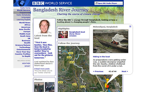
The Bangladesh River Journey is a mashup of posts from a BBC World Service trip to track the effects of climate change in Bangladesh. The trip lasts a month, with photos being posted to Flickr, messages sent to Twitter and journal entries made on the World Service site. The mashup puts all these posts on to a map, letting you navigate around and follow the trip.
The journalists are equipped with a GPS navigation device. Each time they visit a new location, they post their co-ordinates to the Twitter stream (e.g. this post). Our system then logs the coordinates and applies them to every photo, tweet and diary entry until the next location.
In addition to what you see in the browser, there are a number of gems hidden under the hood: microformats, geoRSS and an API. (Non-techie folk may happily skip this and proceed straight to comments :)
Microformats

Microformats are new, developing standards for adding extra meaning to the HTML of a web page. They create all sorts of possibilities for software (from search engines to browsers) to interact with the content in innovative and useful ways.
The HTML for each Twitter, Flickr and diary post in the Bangladesh River Journey is written using the hAtom microformat. This means, for example, that an RSS feed can be generated directly from the HTML on the page.
If you use the Firefox browser, you can explore other microformats on the Bangladesh Boat site, with the excellent Operator extension. You’ll find xFolk bookmarks, geo locations, hCalendar events, hCard contacts, xoxo lists and tagged links:

GeoRSS
The site’s RSS feed allows users to stay up-to-date with new posts, without needing to re-visit the site (we talked about using RSS in a previous post).
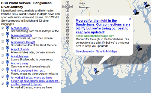
The feed is encoded with the geo coordinates of each post (this is called GeoRSS). Some interesting things can then be done with the feed, such as plotting it straight on to Google Maps:

API
Part of the task was to build an API – a way for web developers to access the data in the system, to create their own mashup applications. This will be promoted through BBC Backstage – the BBC’s hub for exploring new media technology. More about this soon…
Update: The Bangladesh River Journey API is now live on BBC Backstage. Inspired by Google’s addition of a Greasemonkey API to Gmail (via), we added an experimental Greasemonkey API to the Bangladesh River Journey site.
Update: We added KML as a data format to the API. This allows you, for example, to view the entire journey of posts in mapping applications like Google Earth.
Dharmafly & the BBC
It has been fantastic working with the BBC crew. Everyone has shown their good-nature and team-spirit… and nothing but excitement for exploring new forms of media in reporting events that matter to the world.
Our own team was:
- Me, as technical director and coder of HTML, JavaScript and additional CSS
- Annesley, who authored the rock-solid PHP / XSL back-end
- Pete, who scripted the water-tight CSS theme
- Mikel, who contributed mapping strategy and the out-of-the-box balloons
With thanks to Toby Travis, for JavaScript inspiration.
Update: This Project Won Awards
14th May, 2008
The Bangladesh River Journey was declared a Webby Awards Honoree and won the Sony Radio Multiplatform Award. See our later blog post for more information.


6 Comments
It was a pleasure to have worked on such an interesting project with you, and a pleasure to have work on Aunty Beeb’s website.
I told my mum. She’s well proud!
a very interesting and well made site
fascinating stuff!!!
Yes, this great
Thanks for explaining some of the tricks. Congrats on the awards.
inspiring! finally i can sell mashups to our customers…
regards, maurice
I like your essential information about Microformats. I’m preparing my dissertation on this topic. Your info gave me some ideas. Thank you!
Regards, James
12 Trackbacks
[…] There’s very live coverage of the journey. The reporters are taking photos on flickr and posting updates on twitter. Of course, it’s all on a Google Map. One really nice geekity are locations reported from the field via location nanoformats, ala twittervision. There’s GeoRSS, microformats, and an API (dharmafly has more on this on their blog). […]
[…] of the Bangladesh cyclone – and to watch them flow through the Bangladesh River Journey site we built for BBC World Service. The project’s original aim was to expose the very real presence of […]
[…] to digest! No wonder people are scratching their own itches with microformats and XFN. Check out this page to see what I’m talking […]
[…] rather than the nanoformats (”l:lat,lon”) used in TwitterVision and Bangladesh Boat Journey. I think nanoformats are potentially more flexible and already being used, so why invent a new […]
[…] rather than the nanoformats (”l:lat,lon”) used in TwitterVision and Bangladesh Boat Journey. I think nanoformats are potentially more flexible and already being used, so why invent a new […]
[…] the information in useful ways. For some ideas about how to interact with microformats, see the Bangladesh River Journey […]
[…] BBC World Service’s Bangladesh River Journey (see Figure 10) used geocoded Twitter messages to synchronise the location of a stream of different […]
[…] Bangladesh River Journey, a mini-site that we built for BBC World Service, has recently received two prestigious awards. […]
[…] not long after we built the award-winning Bangladesh River Journey mini-site for the BBC World Service, we were asked for another helping of social media […]
[…] Bangladesh River Journey, a BBC World Service project to track climate change, for which we built the interactive mini-site, […]
[…] not long after we built the award-winning Bangladesh River Journey mini-site for the BBC World Service, we were asked for another helping of social media […]
[…] things that end up just aching to be done. Job number one: fix a bug that popped up in our old BBC Bangladesh River Journey web app. We needed to re-implement our use of an undocumented Google Maps feature (oh ho, it seemed […]